
Alpha Series AL3-32
PHOENIX LiDAR SYSTEMS

Multi-Platform LiDAR Solutions
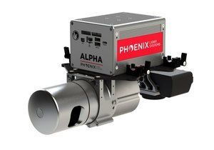
Alpha Series AL3-32
Enhanced accuracy, multi-platform high definition LiDAR mapping system.
The Alpha AL3-32 is the lightest, highest density and most accurate survey grade 3D laswer mapping system in the world. Designed from the ground up to meet the needs of the most demanding surveying and terrain professionals.
Features
- Survey-grade (cm-level) accuracy with 105m laser range and excellent intensity calibration
- Fully autonomous, can be mounted on any drone, car, boat and/or even backpacks
- Modular upgrade options: Dual LiDAR Sensors, DSLR, GeniCam, GigEVision, thermal, multispectral, hyperspectral and custom sensors
- Accuracy independently verified by a third-party, ask for a copy of the white paper
- Easily upgradable to future LiDAR sensors
- Designed by surveyors for surveyors
Specs
- Absolute Accuracy:
25 / 35mm RMSE @ 50m Range - PP Altitude Heading RMS Error:
0.009 / 0.017° IMU options - Weight:
3.2 kg / 7 lb - Overall Dimensions:
29 L x 14 W x 22 H (cm) - Laser Range:
107 m @ 60% - Scan Rate:
700k shots/s, up to 2 returns